Greeley Ponds Trail is rated as an easy hike but there are some water crossings, the largest one is just as you start the hike near the Kancamagus Highway. The trail is about 7.0 miles. This is a great hike for families. There are a lot of roots but besides the water crossings and the roots its just a little more than a stroll in the woods. When you reach the ponds you will notice Lower Greeley Pond is much more shallow than Upper Greeley Pond.
Greeley Ponds Trail is great for snowshoeing also, so the trail is a perfect year-round trail, keep in mind the water crossings can be quite difficult after a heavy rain, or in the springtime.
If you enjoy fly fishing be sure to bring your fishing gear as the trout fishing at Greeley Ponds can be quite enjoyable and is a nice secluded spot.
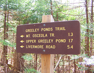
Greeley Ponds trailhead can be accessed at the hairpin turn on the Kancamagus Highway. The Greeley Ponds Trail heads South from the parking area and connects to Flume Path, Scaur Trail (not Scaur Ridge Trail) to “The Scaur,” Tripoli Rd., Mt. Osceola Trail (1.3 miles), Upper Greeley Pond (1.7 miles), and Livermore Rd (5.4 miles). Greeley Ponds Trailhead and parking GPS coordinates are: N44° 01.889 | W071° 30.992 (elevation – 1,960′)
Have you hiked Greeley Ponds Trail? Post information and photos of your hike below!