The Downes Brook Trail, UNH trail and the Mt. Potash hiking trails all head South from the Kancamagus Highway. They are rated as moderate-difficult, the season has a lot to do with the difficulty of many trails, but a little bit more on Downes Brook Trail. Springtime it is a bit more difficult.
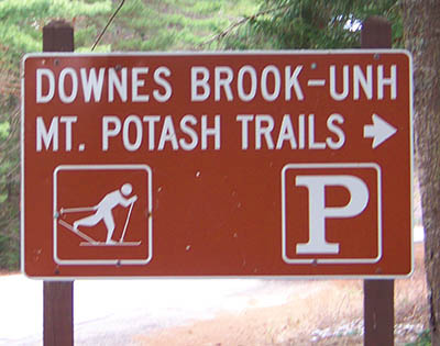
Downes Brook trailhead and parking area is across from the Passaconaway Historic Site and Passaconaway Campground.
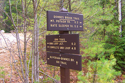
Downes Brook Trail heads towards the West side of Mt. Passaconaway. The UNH Trail Loop is a 4.8 mile trail that returns to the parking lot. The Mt. Potash trail takes you to the 2,870′ Potash Mountain. Also included is the Kate Sleeper trail 5.2 miles from the parking area, and the Oliverian-Downes Brook cross country skiing trail.
Trail parking lot GPS coordinates are: N43° 59.652 | W071° 22.159 (elevation – 1,215′)
Have you hiked Downes Brook Trail, MT. Potash Trail, or Kate Sleeper trail? Post information and photos of your hike below!