There are cross country skiing trails along the Kancamagus Highway. Below are details about all of the XC trails that lead from the Kancamagus Highway.
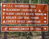
The Nanamocomuck Cross Country Skiing Trail
The Nanamocomuck cross country skiing trail is a family friendly, easily accessible XC trail with plenty of parking and bathrooms at the trailhead. Trail parking is located at the Albany Covered Bridge Parking Lot. The GPS Coordinates for the parking lot are: N44° 00.291 | W071° 14.472
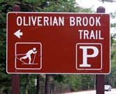
Oliverian Brook Trail
The Oliverian Brook Trail on the Kancamagus Highway is also used for cross country ski trail in the Winter months. The trail heads straight South from the parking area towards Passaconaway Cutoff. Oliverian Brook Trail parking lot GPS coordinates are: N43° 59.642 | W071° 21.025 (elevation – 1,248′)
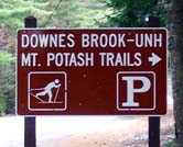
Downes Brook Trail (Aka Oliverian-Downes Brook cross country ski trail)
The Downes Brook trail heads South from the Kancamagus Highway parking area across from the Passaconaway Historic Site and Passaconaway Campground. The Downes Brook trail heads towards the West side of Mt. Passaconaway. the Oliverian-Downes Brook cross country skiing trail. Trail parking lot GPS coordinates are: N43° 59.652 | W071° 22.159 (elevation – 1,215′)
Also see: Hiking Trails at the Kancamagus Highway